Coastal Waters Monitoring Program


Winter 2019 – Draft Outline
Kathleen Ryan
Saugeen Ojibway Nation Environment Office
Last Update: February 6 2019
PREAMBLE
The interaction between Bruce Power’s (“BP”) Bruce Nuclear Generating Station (“BNGS”) and the environment has been an ongoing issue for the Saugeen Ojibway Nation (“SON”) since its inception. Thermal effects and impingement/entrainment represent two major areas of concern. The context of these concerns is based in the Aboriginal and Treaty rights held by the SON and the responsibilities of the SON as caretakers of the lands and waters within their Territory.
It is important to recognize that the People of the SON hold a special relationship with the Water, and with all beings that inhabit the Water. This relationship is based on cultural ways of knowing, understanding, and living in this world in a good way; this relationship has existed since the beginning, since time beyond memory. SON relates with Water as that which brings and sustains life, both to the People and to all of Creation. It is this sacred relationship that makes it imperative that SON uphold their duty to care for and protect the Water.
It is in recognition of the sacredness of the Water that an understanding of the importance of these issues to SON, as well as SON’s own perceptions and evaluations of “risk” and “impact” become apparent. Recognition of SON’s valuation and perception of risk are essential as they inform others with different worldviews, culture, and connection to the lands and waters in the Territory about how the SON develops its criteria and process for evaluating acceptable levels of impact.
After many years of engagement on this issue, it is clear that there are significant gaps in the SON understanding of the existing environment and the interactions and impacts of BNGS on the ecology of Lake Huron (even at a local scale). SON aspires to understand these impacts better by becoming a key part of the design and implementation of more robust programs that assess and monitor the interactions and impacts related to thermal discharge, I/E and the ecology of Lake Huron. SON seeks an active role in monitoring, assessing, and interpreting data that are generated by future investigations.
Efforts to work toward common understanding of the impacts of development(s) and to connecting with our lands and waters have led SON and Bruce Power to work together to develop and implement the SON Coastal Waters Monitoring Program (CWMP). The CWMP will focus on creating space in our discussions for SON’s Traditional Knowledge and understanding of the environment and the interactions of BP’s operations with the coastal environments of the Territory. It will enhance SON’s ability to protect our Aboriginal and Treaty Rights as they relate to the lands, waters, human and non-human beings of our Territory.
This program will be a valuable tool towards building on positive and productive engagements between SON, BP, and CNSC regarding BP’s on-going operations. Further, it will assist in building capacity at the community level, in engaging our community members, and ensuring Anishnaabe knowledge systems (including Anishnaabe science) are at the core of our understandings and interpretations.
Another important aspect of this work is the manner in which it will support SON in building a comprehensive and consistent baseline dataset of both quantitative data (numbers and measurement-based data) and qualitative knowledge or experience-based data that describes the environmental conditions of the Territory. No single or combined authority (MNRF, MOECP, Conservation Authorities, etc.) in SON Territory holds a comprehensive and consistent baseline dataset/inventory that accurately tracks changes to the ecological communities of Lake Huron, nor have any agencies considered the Traditional ecological and cultural knowledge of the SON Communities. SON’s goal is to amass its own comprehensive ecological database in order to develop a holistic understanding of the ecology and environments of the Territory and to monitor changes to the those ecologies and environments. This will foster our ability to understand cumulative impacts, climate change, and make informed decisions about new developments in the Territory in a holistic and inclusive manner.
Signatories
TABLE OF CONTENTS
Preamble
Key Components of the Coastal Waters Monitoring Program
Monitoring Components
Building Capacity and Stewardship
Partnerships
Study Area
Methodology
Fish Community Monitoring
SON Interactions
Temperature Monitoring
SON Interactions
Coastal Wetlands and Aquatic Vegetation Sampling
SON Interactions
Water Quality
SON Interactions
SON Traditional Ecological and Cultural Knowledge
SON Interactions
Data Management and Analysis
References
Schedule a – Data Sharing Protocol
KEY COMPONENTS OF THE COASTAL WATERS MONITORING PROGRAM
MONITORING COMPONENTS
-
Fish Community
-
Nearshore Fish Community (Fyke, Hoop, Seine)
-
Larval Fish (Larval/Plankton Tow)
-
-
Temperature Monitoring Stations
-
Aquatic/Semi-Aquatic Vegetation and Wetland Community
-
Water Quality
-
SON Traditional Ecological and Cultural Knowledge
BUILDING CAPACITY AND STEWARDSHIP
One of the most important components of this work in 2019 will be to hire and provide necessary training for at least three (3) community members to be employed as part of the environmental monitoring team (the “Technicians”). This program will remove barriers of educational requirements (no diploma or degrees required) and instead invest in hiring passionate individuals who want to connect, learn and experience the environments of their Territory.
PARTNERSHIPS
The CWMP will strive to build and maintain partnerships with community groups in both SON communities, and with other environmental groups working in the Territory (e.g., B’agida-waad Alliance, Neyaashiinigmiing Source Water Protection, Nature Conservancy of Canada, Ontario Nature, Bruce Peninsula Biosphere Association, Lake Huron Coastal Centre, Parks Canada). Partnerships will enhance our program through additional training, funding, collaboration and data sharing opportunities.
STUDY AREA
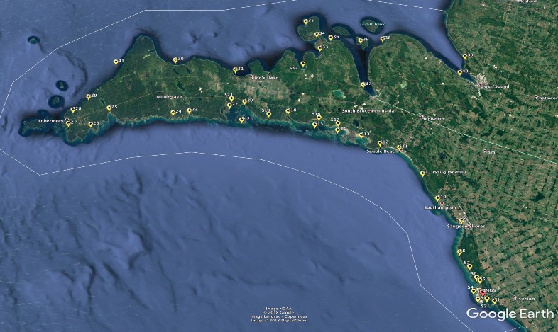
Figure 1: Map of Approximate Monitoring Locations Across the SON Territorial Waters
METHODOLOGY
The methodologies described throughout the following section are based on standard methodologies for sampling, monitoring and analyzing data for nearshore / coastal environments of the Great Lakes, such as those described in Seilheimer and Chow-Fraser (2006), Seilheimer and Chow-Fraser (2007), and Chow-Fraser and Cvetkovic (2011) (See: References section for full details). The frequency of sampling sites during a given year and the exact location of monitoring sites (Figure 1) are subject to change through the first year of this program as we refine and ground-truth.
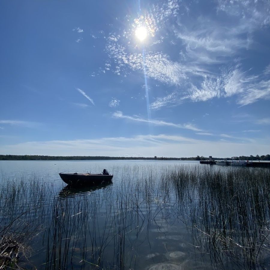
FISH COMMUNITY MONITORING
Coastal sites located across the SON’s Territorial Waters will be selected for nearshore fish community and larval fish monitoring. Sites will be chosen based on existing knowledge of important nearshore/larval fish habitat, previous research, and monitoring in the region, current assessment of fish habitat conditions, accessibility and input from expert knowledge holders in the SON communities. The goal of nearshore fish community and larval fish monitoring is to establish a comprehensive database of baseline conditions for nearshore fish community composition and habitat conditions/characteristics. This will allow comparison of community composition and habitat conditions/characteristics between sites and in the succeeding years enable assessment of changes to fish community composition /conditions/characteristics between sites and across years (once years of data sets are compiled). This data will also be a valuable planning and consultation tool for the SON EO.
Fish community sampling will be done using small mesh fyke/hoop nets, and at some locations (where possible and/or necessary) using small mesh seine nets. All collected fish will be identified and measured (total and fork length). Nets will be set for up to 24 hours to include the diurnal cycle of habitat use by a variety of fish species.
SON is also concerned with understanding more about lake and round whitefish use and habitat in the vicinity of Bruce Power and around the Territory. We will aim to understand the existing habitat for lake and round whitefish across life stages (larval, juvenile, adult / spawning), specifically focusing on the presence/condition of larval whitefish during the spring emergence period, presence/condition of adult whitefish during the fall/early winter spawning season and the condition of the habitats available for use during these critical life stages (e.g., are spawning shoals in good condition or is use impeded by algae coverage?). For example, embayments around the Territory are important larval nursery habitat because of the ability of the morphology of embayments and dynamics of water currents to retain larval fish as they grow and feed on abundant plankton food sources in these areas, however, there are complex dynamics (water currents, temperature, timing of emergence and planktonic blooms) that enable successful growth and survival and the same is true in the adult spawning life stage. Our presence in the waters around the Territory will allow us to understand more about the environmental, habitat, and species conditions which will enhance our overall comprehension on the state and risks to the well-being of the waters and non-human inhabitants of those waters.
The methodologies related to assessing and monitoring adult and larval round and lake whitefish will be developed for deployment during the 2020-2021 field season and this document will be updated as the approach is developed.
The program will aim to sample each nearshore fish community site twice during the sampling season (May – September) and each larval sampling site once during the sampling season (April – June).
Next Steps (2020-2023): Larval fish sampling, larval emergence or egg traps (on shoals), and spawning use / habitat condition surveys with a focus on the vicinity of Bruce Power.
Required Training:
• Fish Identification
• Methodology (use of gear)
• Pleasure Craft Licence
• Boat Proficiency and Operations
Required Equipment:
• 3 Fyke Nets (min) – define sizes
• Seine
• Voucher Jars
• Ethanol
• Measuring Boards
• Large and Medium cooler
• Buckets and scoop nets
• Fish ID books
• Meter stick
• Chest Waders
SON INTERACTIONS
SON
● Provides SON the opportunity to collect the type(s) of fish community data required to construct a fish community baseline.
● Assists in SON’s understanding of the interactions between the conditions created by BP’s and the condition(s) of aquatic biota in the vicinity of BNGS.
● Provides SON the types of data required to understand more about cumulative impacts of development and environmental change across the Territory waters (see above).
Provides input to SON’s baseline database regarding fish community composition and conditions across the Territory waters and assists in decision making about projects / developments across the Territory.
TEMPERATURE MONITORING
Coastal sites located across the SON’s Territorial waters will be selected for installation of temperature monitoring logger(s). Most selected locations will coincide with nearshore fish and/or larval fish sampling and coastal vegetation sites. The goal of temperature monitoring is to understand the temperature dynamics within and across years, and to establish a comprehensive database of the baseline temperature profiles across the Coastal Waters. This will allow comparison of temperature conditions between sites in a given year, within one site across years, and in the succeeding years enable assessment of changes to temperature conditions within and between sites and across years. This data will help us understand variability and fluctuations in the conditions of larval fish, nearshore fish communities, and coastal vegetation communities, as they relate to temperature, both within and across years This data will also be a valuable planning and consultation tool for the SON EO.
Temperature monitoring will be done using HOBO Tidbit temperature loggers and be installed at bottom depth for the duration of the sampling period (May – October). Attempts will be made to install loggers over-winter at select sites, where ice-scour will not cause the loggers to be lost. Loggers will be retrieved by grapple. Temperature profiles will also be recorded using a “sonde” probe at each nearshore fish, larval fish, and coastal vegetation sampling event.
Required Training:
• Proper installation of temperature loggers
Required Equipment:
• HOBO Tidbit Temperature Loggers
• HOBO Temperature Logger Software
• YSI or other Sonde Device for spot temperatures and water column temperature profiles.
SON INTERACTION
SON
● Provides SON the opportunity to collect the type(s) of temperature data required to construct a temperature baseline.
● Assists in SON’s understanding of the conditions created by BP, the condition(s) of aquatic biota in the vicinity of BNGS, and how these conditions compare to other sites around the Territory waters.
● Provides SON the types of data required to understand more about cumulative impacts of development and environmental change across the Territory waters (see above).
● Provides input to SON’s database regarding temperature conditions across the Territory waters and assists in decision making about projects / developments across the Territory.
● Supports other SON community initiatives regarding climate change.
COASTAL WETLANDS AND AQUATIC VEGETATION SAMPLING
Coastal sites located across the SON’s Territorial Waters will be selected for wetland and aquatic vegetation sampling. The goal of wetland and aquatic vegetation sampling is to establish a comprehensive database of the baseline conditions/characteristics for wetlands and aquatic plants. This will allow comparison of the nearshore vegetation community composition/conditions/characteristics between sites, characterization of vegetation communities as fish habitat, and in the succeeding years enable assessment of changes to vegetation community composition /conditions/characteristics between sites and across years (once years of data sets are compiled). This data will also be a valuable planning and consultation tool for the SON EO.
Wetland and aquatic vegetation sampling will occur at all sites where fish community sampling is deployed. Aquatic (submerged and semi-aquatic) plants will be sampled by random quadrat in proximity to the fish sampling gear. Where present, wetlands will be sampled by transect from the water side through the vegetation to a minimum distance of 50 m (or where the wetland meets the shore – whichever comes first). Large wetland systems should include a minimum of 3 transects at 10-20 m intervals. Vegetation species should be identified and recorded each time a new species is visible or at maximum intervals of 5 m where the vegetation community is uniform.
Each site will be sampled once per year.
Required Training:
-
Plant ID training (with Janice Gilbert and others) – In field
-
Study Field Books
Required Equipment:
-
Quadrat squares (4)
-
Field books
-
Vegetation ID books
-
Paper bags
-
Flagging tape
-
Permanent markers
SON INTERACTIONS
SON
● Provides SON the opportunity to collect the type(s) of fish community data required to construct a baseline wetland database.
● Assists in SON’s understanding of the conditions created by BP, the condition/characteristics of wetlands and aquatic vegetation in the vicinity of BNGS, and how these conditions compare to other sites around the Territory waters.
● Provides SON the types of data required to understand more about cumulative impacts of development and environmental change across the Territory waters (see above).
● Provides input to SON’s database regarding wetland conditions across the Territory waters and assists in decision making about projects / developments across the Territory.
WATER QUALITY
Water quality measurements will be taken at all coastal sites selected for nearshore fish community or coastal vegetation community sampling, with additional site selection based on expert knowledge from SON community members or other indicators of special concern. The goal of water quality monitoring is to understand the water quality conditions of coastal locations and to establish a comprehensive database of water quality across the Coastal Waters. This will allow comparison of water quality conditions between sites in a given year, within one site across years and in the succeeding years enable assessment of changes to water quality conditions within and between sites and across years. This data will help us understand variability and fluctuations in the conditions of larval fish, nearshore fish communities, and coastal vegetation communities, as they relate to water quality, both within and across years This data will also be a valuable planning and consultation tool for the SON EO.
Water quality monitoring will be completed at all monitoring locations using the YSI (or other brand) sonde probe to measure basic parameters of temperature, dissolved oxygen, and conductivity, and a secchi disk will be used to assess turbidity. Additional water quality measurements will be taken once per year at representative sites using a “grab sample” technique (samples sent to lab for analysis) to measure for planktonic algae, primary nutrients (nitrogen, phosphorus), heavy metals, and organic compounds such as PCB’s and PAH’s. All water samples will be taken 10m from the emergent vegetation zone to avoid contamination. The specific methodologies will follow the protocol outlined in Steilheimer and Chow-Fraser (2006).
Next Steps:
-
Benthic invertebrates are excellent indicators of water quality. Benthic monitoring will be added to the program in 2020 or 2021 (methodology to be determined – potentially using a passive sampler deployed for set period of time e.g., Hester Dendy.)
-
Sediment samples may be required at some sites where water quality analysis indicates further investigation is required. Sediment sampling will be added to the program in 2021.
Required Training:
-
Basic understanding of how to use collection equipment
Required Equipment:
-
YSI - Sonde for temperature, dissolved oxygen, and TSS
-
Water sample bottles (and sampling / analysis methodology)
SON INTERACTIONS
SON
-
Provides SON the opportunity to collect the type(s) of water quality data required to construct a baseline database.
-
Assists in SON’s understanding of the conditions created by BP, the condition/characteristics of water in the vicinity of BNGS, and how these conditions compare to other sites around the Territory waters.
-
Provides SON the types of data required to understand more about cumulative impacts of development and environmental change across the Territory waters (see above).
-
Provides input to SON’s database regarding water quality conditions across the Territory waters and assists in decision making about projects / developments across the Territory.
SON TRADITIONAL ECOLOGICAL AND CULTURAL KNOWLEDGE
SON’s Anishnaabe ways of knowing and understanding the environment and the environmental science within our own ecological and cultural knowledge system are of paramount importance in the Coastal Waters Monitoring Program. There are various ways of describing these ways of knowing, for our purposes here we will use the term “SON’s Traditional Ecological and Cultural Knowledge” to describe the distinct knowledge and understandings that People in the SON Communities have about the environment of their Territory. This type of knowledge is almost inextricably both ecological and cultural in nature. Traditional Ecological and Cultural Knowledge is anchored by “place” (the Territory), passed on through generations and across families, can be transmitted through story and / or ceremony, is action based (learn and understand through doing), and has depths and complexities that are beyond those of Western science.
This rich information will be integral in shaping our understanding of the longer-term cycles and dynamics of the environment of the Territory and the behaviours and ecologies of non-human beings in the Territory. This will also be part of knowledge transmission, shaping our contemporary understandings of our relationship to, interaction with, and impact on our Mother the Earth. This information will be an essential part of our interpretation of the data gathered through the monitoring and assessment program and define how we modify the program year-to-year as our understanding of the Territory grow.
Workshops will be held within the SON communities to begin the process of knowledge sharing and recording to assist in our identification of significant sites and to build our understanding of the conditions of sites across the Territory through people’s first-hand accounts. Active hunters, harvesters, and fisher-people will be integral in shaping our understanding of the dynamics of the Territorial Waters, and in accounting how the ecology of the region has changed throughout people’s lifetimes, and the lifetimes of those who are no-longer with us, but have passed down their knowledge and stories.
Individuals will be invited to participate in focused one on one interviews with a land-use and knowledge mapping component, to anchor knowledge in place and to create a record of knowledge, use, and stories about the coastal lands and waters of the Territory. Mapping methodologies will follow the principles outlined by Tobias (2010) “Living Proof: The Essential Data-Collection Guide for Indigenous Use-And-Occupancy Map Surveys”.
Traditional Ecological or Cultural knowledge shared by an individual as part of this program will never be distributed or shared with Bruce Power (or outside of SON) without explicit consent from the individual (See: Schedule A).
Required Training:
-
Interview skills
-
Mapping skills
Required Equipment:
-
Base Maps (paper)
-
Voice Recorder
-
Video Camera
-
Laptop (data recording)
-
Mapping Toolkit (markers, rulers, magnifying glass, place marker)
*This work also requires third-party involvement to produce, digitize and process paper maps and transfer data to shapefile / GIS database format.
SON INTERACTIONS
SON Ecological and Cultural Knowledge
(See Schedule A: Data Sharing Protocol)
SON
-
Provides SON the opportunity to ensure its engagement with BP regarding environmental issues is reflective of the knowledge, concerns and perspectives of SON membership.
-
Assists SON’s understanding of the perceptions of SON members regarding BP and its operations, provides direct observational knowledge and science regarding the condition of and changes to the Lake and aquatic communities over-time.
-
Provides input to SON’s database regarding knowledge of how the environment of the Territory has changed over time (decades and longer) and its current state, and assists SON in decision making about projects / developments across the Territory.
-
Provides SON an opportunity to record and preserve TEK for use and reference by future generations.
DATA MANAGEMENT AND ANALYSIS
Field data will be collected using GPS units (location) and paper record keeping forms. These forms will be input to Microsoft Excel both during and after the monitoring season. All paper record forms will be photo-copied and stored as both paper and digital copies. Microsoft Excel files will be backed up to an external hard-drive and stored off-site. Alternate input and storage techniques will be considered throughout the program.
Analysis techniques will evolve as we further refine this program and develop specific research questions and/or required uses. Basic statistical analysis will be performed using Microsoft Excel, and more in-depth analysis using statistical software in R.
Comprehensive evaluation systems have been developed for assessing the condition of Great Lakes coastal wetlands. This evaluation system includes indices for wetland plants (Wetland Macrophyte Index), water quality (Water Quality Index), and wetland fish (Wetland Fish Index), as described in Steilheimer and Fraser (2006), Chow-Fraser (2006), Croft and Chow-Fraser (2007), and Chow-Fraser and Cvetkovic (2011) (See: References). This is one credible analysis technique that can be used to assess and compare the relative quality of nearshore habitats. As we further develop our program and analysis, we may find additional metrics or indices that will be useful in our analysis and interpretation of data.
REFERENCES
Chow-Fraser, P. (2006). Development of the water quality index (WQI) to assess effects of basin wide land-use alteration on coastal marshes of the Laurentian Great Lakes. Coastal wetlands of the Laurentian Great Lakes: health, habitat and indicators. T. P. Simon, & Stewart, P.M. Bloomington, Indiana, Indiana Biological Survey: 137-166.
Chow-Fraser, P., & Cvetkovic, M. (2011). “Use of ecological indicators to assess the quality of Great Lakes coastal wetlands.” Ecological Indicators 11: 1609-1622.
Croft, M. V., & Chow-Fraser, P. (2007). "Use and development of the wetland macrophyte index
to detect water quality impairment in fish habitat of Great Lakes coastal marshes." Journal
of Great Lakes Research 33(Special Issue 3): 172-197.
Croft, M. V., & Chow-Fraser, P. (2009). "Non-random sampling and its role in habitat conservation: a comparison of three wetland macrophyte sampling protocols." Biodiversity Conservation 8(9): 2283-2306.
Seilheimer, T. S., & Chow-Fraser, P. (2007). "Application of the wetland fish index to northern
Great Lakes marshes with emphasis on Georgian Bay coastal wetlands." Journal of Great
Lakes Research 33(Special Issue 3): 154-172.
Seilheimer, T. S., & Chow-Fraser, P. (2006). "Development and use of the Wetland Fish Index to assess the quality of coastal wetlands in the Laurentian Great Lakes." Canadian Journal of
Fisheries and Aquatic Sciences 63: 354-366.
Tobias, Terry N. Living Proof: The Essential Data-Collection Guide for Indigenous Use-and-Occupancy Map Surveys. Ecotrust Canada, 2010.
SCHEDULE A - DATA SHARING PROTOCOL
One of the shared benefits of the CWMP is that both SON and Bruce Power (and the Regulator(s)) will gain more in-depth knowledge (in the form of scientific data and First Nations traditional ecological and cultural knowledge) about the coastal environment(s) of Lake Huron and Georgian Bay. This information will assist both SON and Bruce Power in making better decisions based on mutual discussion and understanding of the data and information collected, and how SON evaluates risks and impacts to humans and non-human beings, the environment, and the exercising/expression of Aboriginal and Treaty rights within the Territory.
Conditions
-
SON agrees to share collected data with Bruce Power on a yearly basis.
-
Bruce Power agrees to share any data from additional nearshore, larval or other sampling programs with SON.
-
Bruce Power agrees to share fish impingement data with SON on a monthly basis.
-
SON and Bruce Power agree to review and discuss such data together twice yearly.
-
Both SON and Bruce Power understand that our respective analysis and interpretation of this data may be different.
SON will share all scientific data with Bruce Power, with the exception of data related to traditional ecological and cultural knowledge that may be sensitive or confidential. This type of information will only be shared or utilized within SON. No traditional ecological or cultural data will be shared without explicit permission from the individual who shared the information.